Thursday, March 31, 2011

Ultra Aid Stations from Ultrarunning Magazine

Aid Station Expertise


by Gary Dudney

This is a very good article on ultra aid stations that I copied from Ultrarunning Magazine.  I hope they don't mind.  I have added a few comments.  They are typed in RED.

One of the great joys of ultrarunning is arriving at a long-anticipated aid station. It can be salvation, pure and simple. Friendly voices and helping hands reach out to you. Everything you need to replenish yourself is right at hand. You load up and you’re ready for the next section of trail. At least, that’s what should happen. Getting the most out of an aid station, however, requires some thought. And you sure don’t want to get a mile down the trail only to discover you forgot to take care of some critical business.

If you’re brand new to ultrarunning, the first time you see an ultra aid station will be a revelation. Aid stations in marathons are fairly simple affairs. Most of the time, they’re there exclusively to give you fluids and keep you speeding toward the finish. If you’re also offered some Vaseline smeared on a piece of cardboard, energy gel packs, or even cut-up bananas, you’ve hit the mother lode of marathon aid stations.

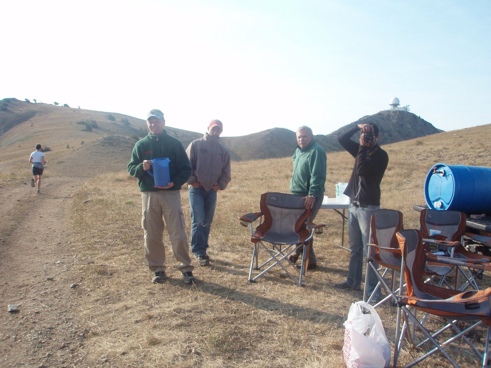
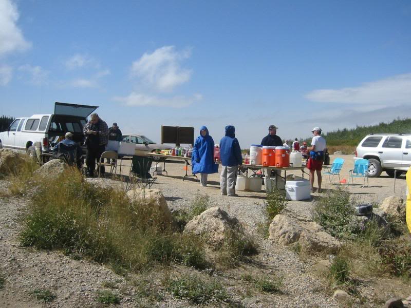
Aid stations in an ultra offer much, much more because they serve a larger purpose. In addition to the fluids vital to the runner, including water, soft drinks, and sports drinks, the aid station will have a rich variety of food: cut-up fruit, peanut butter and jelly sandwiches, cooked potatoes, energy bars, chips, pretzels, candy bars, cookies, and other foods critical to supplying the calories necessary to maintain your energy level in an ultra-distance event. Salty foods will be available and usually an accompanying bowl of salt handy for dipping chunks of food in to help with salt replacement. More elaborate aid stations will also have soup, turkey and cheese sandwiches, breakfast items, and specialties like tortilla wraps or burritos. Ice is another ultra aid station staple, crucial on hot days for cooling off fluids and filling hats and bandanas to keep runners from overheating back on the trail.

The volunteers at the aid stations in ultras are often experienced ultrarunners themselves and are usually very helpful. They can assist runners with mixing energy drinks, adjusting clothing, or finding needed items; they provide information about the next stage of the run, and they can often administer basic first aid when needed. They also offer considerable moral support during the race. Some aid stations double as drop bag sites where you get access to your own supplies prepared before the race. In longer events, aid stations can be designated as crew stations as well, where you can meet your crew and pick up pacers.

With so much at stake at the aid station, it’s worth getting things right. But arriving at an aid station can be overwhelming and disorienting. The energy of the volunteers, the crush of other runners, the bewildering array of food out on the table, the sudden transition from quiet concentration to shouted questions, and the general hubbub can all conspire to wipe your game plan out of your mind. It can also be quite exciting and distracting to see your crew or family members at an aid station after the solitude of the trail. The key is to be prepared.

Before you arrive at an aid station, think systematically through what you need to accomplish. Your list might be something like this:
  • Fill bottles with half sports drink, half water
  • Eat a sandwich and some potatoes with salt
  • Ask for some extra electrolyte caps
  • Check the hot spot under the arch of right foot
  • Put some ice under hat
This step is important.  On several occasions I have gone through an aid station and left without filing one of my 10 oz Nathan bottles holding Perpetuem.  I ended up running several miles without this energy drink that I depend on.  I also "usually" forget to empty pockets of trash, usually empty, sticky gel packs.  Think Ahead!

When you see the aid station off in the distance or get some other indication that it is near - like voices, music, or generator noise - get your bottles out and loosen the lids. If you’re using a hydration pack, have it unstrapped and ready to take off. Take out your electrolyte drink mix if you’re going to mix your own fluids. The idea is to have everything ready to go for the volunteer to fill your containers or for you to fill them as soon as you arrive. You want your time at the aid station to flow efficiently. You’ll get a restful break from the running, but you don’t want to waste time.

Relax and gaze over the food choices with your checklist of concerns in mind. You might choose to chug some extra sports drink if you’ve been drinking primarily water. On a hot day you might focus on the salty foods and take advantage of the bowl of salt, dipping in a piece of potato. You might need to catch up on eating solid foods and opt for eating a whole sandwich. If you’re nearing the end of the race, a blast of sugar from a soft drink might give you just the extra energy needed to finish. While you’re eating, you can be asking a volunteer about the upcoming section of the course. The distance to the next aid station or knowing that you face a tough climb might help you decide to adjust your fluids. Be sure to deal systematically with each of the issues on your checklist.

Before you leave, double check you’ve got everything with you and make sure your water containers have indeed been filled. I’ve had to share water with a runner at Western States whose empty hydration pack was returned to him “full up.” Select some food from the table to take with you. Give everyone a hearty thank you and get out of there. Enjoy walking briskly and eating for awhile before you get back to the running.  
This one is critical!  So far I have left my cue sheet and backup flashlight at an aid station in the Pinhoti in '08.  Later in that same race, at the Pinnacle aid station, mile 74.5, I ran off and left my water bottle and had to run back 300 or 400 yards.  I Leadville, I forgot to drink anything at Twin Lakes, outbound, and ran out of water going up Hope Pass.  At the Katcina Mosa 100K, I didn't check to see how much water I had going up to Lightning Ridge in 100 deg. temperatures and totally ran out half way up a seven mile climb.  At Wasatch, I lost my wife, Marye Jo, at  Brighton aid station.

The stakes get higher and processing efficiently through the aid station can be more challenging at one of the later stops in a longer event like a 100-mile run. Exhaustion, pain, and relief at arriving can all conspire to make you forget what you need to accomplish. It is more important than ever to focus on your list of issues and be sure you’ve dealt with each one before moving on. If you’ve prepared a race plan ahead of time with instructions on what needs to be done at each major aid station, follow it to the letter. If you have a drop bag, it’s not a bad idea to spread out a hand towel (packed in your drop bag ahead of time) and empty the contents right out on top of it. Seeing everything will help prompt you on what you need to do, for example, change into the long-sleeved shirt or take along the extra bag of electrolyte capsules and energy gels.

Meeting your crew will add another dimension to your aid station visit. An experienced crew member can shoulder a lot of responsibility in getting you ready for the next leg of your journey. On the other hand, well-meaning but less-experienced crew members can add to the confusion. Once, a crew member pulled a baggy full of electrolytes and painkillers, meant for use over the next 25 miles of the race, out of my running belt. Unbeknownst to me, he stuck it in the crew bag rather than returning it to my belt. I was well down the trail before I discovered I was going to have to do without my pills for the next several hours of the race. In the end, accept help graciously, but be aware that the final responsibility for knowing that you have what you need and are ready to leave the aid station rests with you.

There are two distinct camps on the advisability of actually sitting down and resting at aid stations, especially late in bigger races. Some caution “beware the chair” and hold that runners are tempting fate by getting comfortable. Others believe the rest is beneficial. Some runners can even take catnaps and wake up after a ten-minute snooze with renewed vigor. Sitting or not sitting seems to be an issue that each runner needs to learn about individually.
Getting the most out of aid stations will take some practice. Once you’ve mastered the art, though, you’ll find yourself experiencing a nice solid “bounce” after each aid station, and you won’t be kicking yourself for forgetting to fill your bottle or failing to sit down to take that rock out of your shoe.

A couple of other comments.  The author of this article said in the opening paragraph, "One of the great joys of ultrarunning is arriving at a long-anticipated aid station.  It can be salvation, pure and simple."  You cannot imagine how true this is.  Five miles in an ultra can seem like an eternity, especially if you will be meeting your crew at the next aid station, in my case, Marye Jo.  At Wasatch, after the start, I did not see her for over 12 hours.  Sometimes it can even be a little difficult to head back out again, especially when you are running off into a very cold night.  Even from back in my marathon running days I always ran from one aid station to the next.  I never thought beyond that next AS.  I found it discouraging to think too far ahead.


In ultras, thinking too far ahead can be downright scary.  I simply focus on the next aid station, the next climb, the next change in running surface or the first view of The Twin Lakes at Leadville.  Just like Zig Ziglar always said.  Break the big goal down into small, manageable goals.  Focus on achieving each small goal, one at a time.  Before you know it, you have accomplished the big goal.  I think he said it a little better than that, but you get the idea.  Just reach that next aid station.


Tuesday, March 29, 2011

More Aid Stations - Leadville

The previous post showed the type aid station you will encounter about 90% of the time in you standard 100 mile, 100K, 50 mile and 50K race.  I can't be sure about 50 mile races, I have never run one.  When I ran Leadville in 2009, I had only run one other 100 mile race, the Pinhoti 100 here in Alabama. That was also the first year for the Pinhoti.  I may run it again this year to see if I can do a little better with more knowledge and being in a lot better condition.  I have not been able to run Pinhoti the last two years because I ran the Florida Ironman which takes place the same weekend in November.  I am tired of dealing with weather problems associated with the open ocean swim in November, like really rough water and 39 deg. temperatures at the start of the swim.  I plan to enter the Houston Ironman to be held in May 2012.  If I don't run Pinhoti I will help.

The following aid stations are the other 10%.  The first group below are from Leadville.  I tried to find pictures from inside the tents but no one seems to have taken any.  The main reason for the large aid stations is the sheer size of the race.  During the Outbound half, the aid stations are crowded with with runners and their crews.  Even on the inbound side of the course, there is still a lot of congestion a each aid station.  There is also another reason.  Every aid station is very accessible and not very far from Leadville.  The only time you ever leave the pavement is the drive up to Winfield and that road is very well maintained and can be reached by any rental car.

This is the first aid station and the last.  May Queen at mile 13.5 and 86.5.  I never saw it in the dark.  By the time I reached it the first time, it was getting light.  When I arrived on the way back, it was getting light again.

Another shot of May Queen, just so you can tell how big it really is.  It contains drop bags, a lot of chairs, a medical area, cots and about 1/3 is food and drink. Here is a video from YouTube of someone coming into May Queen, outbound.  May Queen.

The Fish Hatchery, outbound it is just after descending from Sugarloaf Pass at 11,071 ft.  It is located at mile 23.5 and 76.5 on the way back.  When you leave here inbound, the "Powerline" climb is next.  The actual aid station is located in a building to the right just out of sight in the picture.  It is as large as May Queen. 

This is Box Canyon aid station, used in 2009 instead of Half Moon Campground.  The distance varies.   I arrived at this aid station sometime in the middle of the night on the inbound leg.  It looked like May Queen, volunteers everywhere, music playing and just as many lights.  That will wake you up. 

That is Anton Kruprika, Leading the 2009 race as he left the Twin Lakes aid station.  It is located at mile 39.5 and 60.5.  He was still in the lead I encountered him about two miles from this spot as I was heading for Hope Pass.  He was headed back to Twin Lakes and about a mile ahead of the second place runner. (At least I finished!)

The Hopeless Aid Station, mile 45 and 55.  This aid station is located at 11,836 feet, right at timberline on the climb up Hope Pass just 700 feet below the crest of the pass at 12,526 ft.  Everything at this aid station must be hauled up from Twin Lakes, 5 miles and 2,600 feet below.  They use Llamas.

Here is a link to YouTube of someone arriving, Inbound, at Hopeless.

The ghost town of Winfield. Halfway home!

Of course, when comparing Leadville to other 100 milers you must remember one thing.  It is the larges and one of the oldest 100 mile races.  It is probably the best known of all, even among the non-ultra running population.  "Born to Run" didn't hurt it fame either.  The next picture is of the start.  It looks more like the start of the NYC Marathon in the dark than any other 100 mile race you will ever run.  It sold out this year at something in the neighborhood of 700 runners.

Running Leadville was a totally different experience than any trail race I have ever run.  There was never a time in the race where there were not other runners around, even in the middle of the night.

In the 1870's and 1880's Leadville was a thriving silver mining town with a population as large as 40,000.  The Climax Molybdenum Mile kept the town alive until the early 1980's.  At the race's inception, Leadville was experiencing another bust cycle after the closing of the Climax Molybdenum Mine resulted in nearly 3,000 miners losing their jobs.  LT100 founder Ken Chlouber was one of those miners and conceived "The Race Across the Sky" as a way to make Leadville famous and bring in visitors during a period of economic downturn. In the beginning, there was just one foot race; 45 racers lined up at 6th and Harrison to take on the challenge. Only ten racers finished.  I think Ken succeeded in making Leadville famous.

Monday, March 28, 2011

Aid Stations

Aid Stations in 100 mile runs come in every imaginable size from water only to a dizzying variety of food and drink.  Sometimes they even have a "theme."  My first 100, Pinhoti, was pretty basic except for the aid stations atop Mt Cheaha at Bald Rock in Mt Cheaha State Park, at mile 40.9 and Adam's Gap at mile 55.3.  Up until Cheaha, the aid stations had water, Heed, coke, chips, cookies and fruit.  I am not sure what other types of food was available at Cheaha but there were a bunch of people there offering all kinds of help.  I grabbed my drop bag and changed into warmer cloths for the sub-freezing night, put on my headlamp and left my cue sheet and flashlight in the bathroom at the state park.  I didn't take time to eat anything except maybe a banana.  One mile later I was descending "Blue Hell" as it is known in the Cheaha 50K just as the sun was setting and it was beautiful.  That was also when I realized I did not have my flashlight and cue sheet.   The Cheaha 50K runs in the reverse direction over much of the same trails as the Pinhoti so it climbing up the 1,000 foot, one mile long section, to the top of Cheaha called "Blue Hell".

Here are a couple of the "basic" aid stations from Pinhoti.
I think this is Aid Station #1 at miles 6.7

Chandler Springs aid station #12 at mile 65

Some of the aid stations at Wasatch were just as basic as you will see below.  Again, most pictures are from Chihping Fu of Fremont, California.  I did get his approval to use them.  Thank you, Chihping.  He is running the Bear 100 this year, which I had planned on running until Saturday.  I received an email from The Tahoe Rim Trail 100 that slots had been added and everyone on the waiting list could register.  I registered immediately.


At Wasatch, Most of the aid stations are very hard to reach.  Some, like Grobbin's, Swallow Rock and Pot Bottom require serious four wheel drive vehicles.  Rock Springs requires carrying everything in, along a miserable and very steep 2 mile long ATV trail.  Almost all are very remote and require a drive up 8 or 10 miles of steep, dirt roads.


 Aid Station #1 Grobbin's Corner at mile 13.35

Aid Station #2 Francis Peak, mile 18.76.

Bountiful B Aid Station, mile 24.

Another shot of Bountiful.

 Swallow Rock Aid Station at mile 34.9.

Alexander Springs Aid Station, Mile 47.4. Almost half way.  That is I 80 in the background and the location of Lamb's Canyon aid station.  The mountains in the background are the peaks above Park City and where we are headed.

Big Mountain Aid Station, mile 39.4.  Marye Jo was there waiting on me.

This is Pole Line Pass Aid Station located at mile 83.4.

Rock Springs, mile 87.3as it looked when I arrived.  Remember, everything had to be carried in from two miles and about 1,000 feet below.

The next post I will show some of the other extreme.


Friday, March 25, 2011

The Last 35 miles of Wasatch - Of course there was 47 miles to go.

First, I borrowed some of these pictures from Chihping Fu of Fremont, California.  He was thoughtful enough to take pictures of the aid stations in his race in 2007.  He finished.  I will use them in this post and in the next.

I arrived at Lamb's Canyon aid station at 10:17PM and left at 10:38.  I spent 21 minutes at the AS and I am not sure why.  I did have to take my shoes off and put on running tights.  Marye Jo had everything ready for me but I was still slow.  I do remember being very tired but I was also excited about the climbs to come.  I was anxious to get up to the ridges above the Canyons and Park City Ski Resorts.  After a little regrouping, I headed out, under I80 and up the Lamb'e Canyon Road. 
The Lamb's Canyon Aid Station and I80.

I remember hiking and running up what seemed like miles on a paved road.  I did not know where we turned off the pavement and I kept thinking I had missed the trailhead.  Then I would see the course flagging and know I was on route.  The wind was howling in the tree tops and occasionally I was hit by a blast of cold air, but in general, there was just a light breeze on the road.  I finally reached the end of the road and there was the trailhead.  I had not seen a headlamp since leaving Lamb's aid station and it seemed pretty lonely out there.  Before Lamb's, there were several other runners in front and behind me but now no one was in sight.  I think they had stayed at the AS longer than I did.

I knew the trail climbed up (1,500 feet in 2.1 miles) and over a ridge and back down to the Upper Big Water (Mill Creek) Aid Station.  As I climbed I began to see other headlamps and ended up following someone up the hill.  Finally we crested the ridge and started down a rocky, more difficult section for a few miles.  We finally came out on a paved road and again I stared hiking and running up pavement for 5 miles.  I passed several people going up the road and after what seemed like hours reached the Upper Big Water AS.  The aid station was out in the open and as I approached I became much colder.  A volunteer found my drop bag, which was frosted over with ice, and I went over in front of a  heater and warmed while resupplying.  I arrived at 1:57 AM and stayed 21 minutes.  I seem to be stuck on 21 minute stops.  I sat in the warmth of a propane heater and ate a cup of hot soup.  Then I gathered my stuff and headed out for Desolation Lake

I remember being very cold as I started up the 5.3 mile climb to Desolation Lake but soon warmed up as  I hiked up the trail in the dark.  It was a spectacularly clear night although I never turned off my headlamp to enjoy it.  As I climbed, I came up behind more runners.  I felt like I was crawling up the hill, but I guess others were as tired as I was.  Soon we crested a small hill (the moraine) and there was Desolation Lake and the aid station.  The "bowl" the lake sat in seemed to hold the cold night air.  It was noticeably colder at the aid station than it had been just a couple of minutes earlier.  They had a large fire burning over about 50 feet, but is was off the trail and I wisely never went near it.  

Desolation Lake (mile 66.9) is a very remote aid station, accessible only by foot or ATV.  In an earlier post, I talked about skiing over to the ridgeline to the right of Lift 9990 at the Canyon's Ski Resort and looking down at Desolation Lake, covered in snow, 1000 feet below.  I filled a couple of Perpetuem bottles, ate more hot soup and headed on out.  I arrived Desolation AS at 4:31AM and left at 4:41, I was doing better.  I could see a couple of runners sitting over by the fire but the guys I had been following started up just ahead of me so I followed.  Now there were 10 or 15 headlamps visible winding up the trail to the crest of the ridge.  I didn't feel alone any more.
Desolation Lake from near the location of the aid station..  
And from above.  I think the aid station is located about where the trail to the right disappears in the trees.  
This picture was probably taken from the trail climbing up to the ridgeline.

We left Desolation Lake and climbed about 1000 feet to the ridge where the lights of , probably Kimble Junction, were visible over the other side. After reaching the ridge "Red Lover's Ridge" we headed southeast following the ridge.  Somewhere near the upper part of the climb is, I think, were I slightly twisted my ankle.  I do remember thinking,  "That would have been trouble last year."  I guess it had not healed as much as I thought it had.
Sunrise in the Wasatch near Scott's Peak Aid Station

After several miles along the ridge, we reached Scott's Peak AS at mile 70.8, just as it was beginning to get light at 6:12 AM.  I ate a cup of soup, again, refilled one Perpetuem bottle and picked up a banana.  I remember being very disorganized and having to search for one of my gloves.  I ended up staying there for 14 minutes.  I don't know what I was doing for that long. I don't even add any water to the bladder.  

We now started the 4.9 mile descent to Brighton Ski Resort at mile 75.6.  Marye Jo would be there waiting for me.  I was a little concerned because she was going to drive over Empire Pass above Deer Valley's Empire Lodge, a well maintained gravel road, but pretty remote for several miles after leaving Deer Valley.  Two or three miles from Brighton, we were back on pavement and that is where my ankle problem began to show itself.  I ran all the way to the lodge and passed several more runners, but my ankle also began to hurt.  As I came in sight of the building where the aid station was located, I called Marye Jo and told here I would be there in a couple of minutes.  She decided to run out and meet me.

We had driven over to Brighton the day before the race to location of the aid station.  She ran back the the way we drove in (the road circling through Brighton is one way.)  The trouble is, the race came up from the other side and we never saw each other.  When I got in to the Aid Station, I found my stuff, but no Marye Jo.  I looked around for her but could not find her.  I went outside to see if she was out front waiting for me, but she was not.  I finally called her.  By then she was about 1/2 a mile down the road I had just run up.  I had no choice but to gather my stuff and go.  It was now 7:45 AM and I had 9 hours and 15 minutes to reach the finish.  I had no time to waist but at my present pace, I would reach the finish safely ahead of cutoff.  
Below are two shots of the Brighton Aid Station outside and inside


Above is Brighton Ski Resort and the Climb up Catherin's Pass.


This is a shot of the climb up Catherin's.  Lake Mary is the flat spot about 2/3 of the way up.  I think the pass is actually on the right side of the picture, but I am not sure.

Some woman at the AS was rushing me and said I would really have to hurry or I would never make it.  She rushed me so much I left my sunglasses and lost my gloves.I was now in a panic, thanks to a well-meaning, member of another team.  I thought she was a race official and that she knew what she was taking about.  I was not thinking clearly enough to realize I was actually fine on time.  I have always finish the last 25 miles faster than other section and after the climb up to Catherin's Pass and on to Point Supreme at 10,480 ft. there were only three minor climbs left, one of about 600 ft and and two, about 800 ft.  The rest was almost all downhill.  She had me convinced I would never make the 36 hour cutoff unless I went all out to the end.  I was so discouraged going up Cathrin's Pass I almost turned around and came back down.  I will never listen to anyone like that again.    

The descent from Point Supreme is very steep and rocky and by now I realized my ankle was going to be a problem although I was still able to run downhill.  I was very tired and started eating Honey Stingers and drinking Perpetuem on a regular basis to recover. I was trying to hurry and reached Ant Knolls Aid Station at 10:10am and spent exactly 3 minutes there.  It was now getting hot and the sun was intense.  I had no sunglasses so I did pull my cap down over my eyes.  I reached Pole Line Pass at mile 83.4 at 11:17am.  This is a drop bag AS so I sat down and took time to sort through my bag and add water and NUUN tablets to the hydration pack.  This time I didn't leave all my supplies from Brighton.  I kept a couple of extra Honey Stingers I had not eaten.  I thought I might need them later.  As usual, I grabbed a peanut butter and jelly sandwich and a banana and started off.
Pole Line Pass Aid Station

After Pole Line the trail climbs for a mile or two before hitting a very steep section that just about did me in.  The climb was probably no more than a 400 or 500 feet, but it was brutal and I was pushing as hard as I could.  After that climb the trail descended about 1000 feet before starting back up to Rock Springs.  This descent was the "final straw."  My ankle hurt going down hill and I could only walk, and slowly.  The uphill was becoming a problem too.  I finally reached Rock Springs at 1:14 PM.  I sat down on a rock to rest and cool off under the tarp they had rigged over the trail. (They have no chairs since everything has to be carried in over a very rough, 2 mile trail.)  I was wearing compression socks and when I looked down at my ankle, it looked like I had wrapped a donut around my ankle under the sock.  I think the compression socks held all the fluid that had accumulated right in place rather than letting it drain down around the lower part of my ankle and foot.  I sat there a few minutes evaluating the situation.  I now had 3 hours and 46 minutes to finish the last 12.3 miles.  Normally, that should be no problem since it is almost all downhill.

Rock Springs, in 2007, they did have chairs, and two tents.

Trouble was, I could not run down hill at all and walking was painful.  I thought I had two aid stations to go and 15 miles.  To this day, I have no idea why I thought that. I was also afraid I would do some really serious damage and really didn't think I could make it to the end.  I wisely decided to stop.  I think that was a good decision.  My ankle still is bothering me a little, and I am doing all my running in an ankle brace.

Next, I am going to post pictures of the aid stations in the first half if the race (since I found Chihping Fu's pictures)  I will also post aid stations from Leadville.  They are an interesting contrast.


Thursday, March 24, 2011

More Wasatch - Water, Electrolytes, Food

Wasatch was the smoothest 100 mile race I have run (to mile87.3- actually to mile 90.)  I had to walk out almost 2.5 miles to where I met Marye Jo.  I think one of the reasons everything went well despite being very tired the whole run (thanks to AF) was that I was using NUUN tablets in my water.  At each aid station I would pull out the bladder from my hydration pack and check the level.  It is calibrated in ounces so I added water in increments of 4 oz so I could add exactly the correct amount of NUUN tablets.  (1 tablet for 16 oz-1/2 tablet for 8 oz - 1/4 tablet for 4 oz.)  The ratio works so well for me that I don't think I ever took any additional electrolyte caps the entire race.  At Lamb's Canyon and Brighton aid stations runners are weighed to be sure they are not becoming dehydrated or over hydrated.  I was within a couple of pounds of my weight at prerace check-in despite having run 53 and 75 miles.

I don't drink or eat on any kind of schedule.  Instead, I just drink a little water every few minutes.  This is much easier when you are carrying handheld water bottles but the hydration pack works fine.  Because I always use the backpack during long training runs I am accustomed to grabbing the hose every 5 or 7 minutes and taking a drink.  Every two or three drinks of water I take a drink of Perpetuem.  In a training run or a race, I will finish off the first 10 oz bottle in the first 1 1/2 to 2 hours, then try to empty one bottle every 1 to 1 1/2 hours for the rest of the race.  As I approach an aid station, I will pull out the 10 oz bottle of Perpetuem I have been drinking from and check the level.  If it is almost gone, I will finish it off before reaching the AS and place the empty bottle back in the belt.  I will then take out a new bottle as I come up the the aid station and hand it to someone to fill with water.  Because the bottle is half full of Perpetuem powder, after the water is added I shake it up and add more water until it is almost full.  At Wasatch, most aid stations were hours apart so usually I filled two bottles before heading out.  If the Perpetuem bottle still had a lot left in one bottle, I would just add water to one additional bottle.

As I mentioned, I always carry some type of gels.  My current favorite is Honey Stinger "Gensting" Energy Gels.  I like the way they taste and they seem to work very well.  I have tried a lot of different kinds and like  most of them, but after 6 or 7 hours I just cannot eat them any more.  With Honey Stingers I can eat them for 30 hours straight with no problem.  A good way to find out what you like is to order an assortment and try them all.  Zombie runner sells electrolyte assortments and gel assortments. You can also stop by a local bike shop and  buy one or two of everything and see what works best for you.

I don't use a regular schedule for gels either.  I just eat one every now and then but try to consume on per hour but it usually ends up being more like one every two hours.  Between the Perpetuem, the gels and what I eat at aid stations, I don't seem to need to eat any more than that.  I have mentioned in the past that I eat what looks good at the aid stations.  Usually, I will grab some or all of the following: half a sandwich (almost always peanut butter and jelly), a couple of chocolate chip cookies, a few potato chips, a slice of orange and a slice of banana.  If they have soup, I will sometimes have a cup, too.  I do not eat all this stuff at the aid station.  I will eat the slice of orange because that takes about 10 seconds, but what ever else I want, I take with me.  I put the banana and the cookies in a pocket and head out with the sandwich or soup.  If I do want both a  sandwich and a cup of soup, I eat the soup at the AS because I don't want to carry the paper cup to the next aid station and I don't want to put a peanut butter and jelly sandwich in my pocket!!  I will immediately start walking and eating.  After finishing the sandwich, I will start running again.  A few minutes later I will pull out a cookie and eat it on the run or walking.  I may not finish off everything for 20 or 30 minutes.

I try never to sit down at aid stations that are not drop bag station.  If it is a drop bag station I do sit down while I sort through everything.  It is easier to lay out what you are leaving, then take out the bag of new supplies and stow them for the next leg.  I try to put things in the same pocket at each drop bag station.  That is, I put the NUUN tablets in the same pocket each time, I leave a chapstick in the same pocket, gels in the same pockets, etc.  If I don't do this I loose stuff I am carrying.  I also carry a baggie of "extras" stashed away in a remote pocket in my pack.  An emergency kit, so to speak.  At Wasatch, I also kept a course map and directions in that same pocket.  I didn't need any of the emergency extras.

There are a few other things you need to keep with you during all races and long runs.  In a 100 mile race you will be on the train over one entire day and night, sometimes in some very remote locations.  I always keep certain items in a baggie in my backpack.  These things are important so I will list them.
   1.  A couple of pouches of sun screen.
   2.  Medical tape (I use Kinesio Tex Gold) precut to two or three lengths.
   3.  Sharp pocket knife.
   4.  A few band-aids.
   5.  A compass.
   6.  A couple of paper towels or toilet paper.  They just don't put port-a-potties where you need them.
   7.  A little cash or a credit card.
   8.  I always have an extra set of batteries in the drop bag where I pick up flashlights and headlamps for the night.  I only carry them over night.
Perhaps the single most important thing to have with you on all training runs and long ultras is a cell phone.  Don't even think about going out alone for a train run without one.  (And charge the battery the night before.)  It can save you life.  Just as important is a "Road ID" bracelet.  If  you do not have one, order one today.


I also put an extra set of contact lenses in a drop bag or two.  You can probably add a few things to this list.

Back to the race, Mile 53, Lamb's Canyon Aid Station.
The Lamb's Canyon AS sits

Wednesday, March 23, 2011

More from Wasatch

I mentioned the pacing strategy I now employ is simply walk up hills, run down hills and run and walk the flats.  What I haven't mentioned is how I determine how fast to go up how fast to run down and how much to run on the flats.  In reality, I can't tell you how I do it.  I think that is one reason to run 50Ks.  You develop s sense of how much energy you can get away with using over a 5 or 6+ hour period (in my case anyway.)  Another thing that helps is having run for 40+ years.  You just develop a sense of how much energy you are using and how long you can continue at a specific rate of "burn."

I can make a few suggestions.  In my first 100 mile race, the Pinhoti, I estimated I could run a 16 minute pace and still finish in under 27 hours.  Then I went out to Veteran's Park and tried to run a 16 minute per mile pace.  I found out it is not possible for me to run that slow.  I tried walking 2 minutes and running 2 minutes and was still moving at a 14 minute per mile pace.  (By running I mean going as slow as I could and still have it qualify as a run.)  I simply could not move at a 16 minute per mile pace.  That is when I decided to try the two on two off plan.  As I mentioned previously, the hills stopped that in a hurry.

At Leadville, I had met several people at the training camp that I knew would be shooting for a 28 or 29 hour finish.  I spotted one of them at the start and tried to run at a similar pace.  I was a little surprised that everyone ran almost all of the first 5 or 6 miles in the race.  I ran behind her for a couple of miles then had to make a quick stop in the woods and rather than try to catch her again I just maintained the same pace, SLOW but running.  (The first 5 miles is almost all downhill or flat.)  After May Queen aid station, the run starts up a section of the Colorado Trail before hitting a well maintained gravel road that climbs gently for a couple of miles.  The course then truns onto a steeper forest service road up to Sugar Loaf Pass.  About half way up the climb I spotted her again so I figured I was going about right.  (She was one of the people that was introduced at the training camp as having finished Leadville more than 10 times.  That is why I choses to follow her.)  A few minutes later I noticed she was not ahead of me anymore so I assumed she must have hopped over into the woods, too.  I never say her again until I was almost back to the Hope Pass Climb from Winfield, inbound.  It was less than 10 minutes until the Winfield cutoff and I knew she would not make it.

At Wasatch I did not worry about pacing.  I just started off about 3/4 of the way back in the pack and ran my usual slow pace.  A few people passed me in the first few miles but mostly I ran with the same people over the lower section and up the first climb until I was slowed by the atrial fibrillation.  There is probably little benefit in trying to figure out what a 14 or 16 minute pace is on a fairly flat course if you your race will be on steep terrain, but at least it gives you a sense of how slow you will need to be moving.  Remember, a 14 minute pace is a 23.33 hour 100 mile pace.  Take a look at the finish results of the race you are running and see how many actually beat 24 hours.  At Wasatch in 2010, over 200 started and 16 finished in under 24 hours.

This is another shot I found from the road along the ridge near Francis Peak.  Of course, we were running in the clouds all along this section so there was no spectacular view like this.


This is the course profile and Aid Station location for Wasatch.

The second half of Wasatch will be next and little more on fueling.

Tuesday, March 22, 2011

Wasatch, the first 53 miles.

Here are pictures of the first 50 miles of Wasatch.  Most of these pictures were taken by Matt Galland during the spring and summer of 2008 and 2009.  They are posted on the Wasatch 100 site.  The pictures with the date stamp "4/11/10" are mine.  I think I need to set the date on the camera since the race was Sept 10 & 11.

Just a few minutes before the start at East Mountain Wilderness Park, Kaysville, Utah.

About 3/4 of the way up the climb to Chinscraper.
Below is my picture from somewhere over the ridge line in the picture above.
Coming up under Chinscraper.
 Conditions during the race were a little different than the picture above on the  approached.


The final climb up Chinscraper.

 My picture looking back down Chinscraper.

Along the trail heading for Thurston Peak.

And this is what that trail looked like on September 10 th.

The Francis Peak radar dome which I never saw even thought the trail passes within a few 100 feet of it.
The dome is visible from the SLC Airport.  If you look out of the windows facing the Wasatch range to the west, then follow the ridge-line to the northwest on a clear day you will see it.

A little of the road near the dome.

  This is the flat section called Skyline, I just don't remember exactly where it was.  I think it might be a few miles past Bountiful B AS.

Somewhere along miles of ridges headed for Big Mountain.


Looking South to the mountains above Park City and Alta.

And more ridges.


I think this is the Shallow Rocks Aid Station.

Past Big Mountain Aid Station headed for Alexander Springs.  This is the lake near I80 just a couple of miles below Lamb's Canyon Aid station.

Headed down to Alexander Springs aid station.  That is I 80 in the distance.

The grassy section we ran on for several miles.

Location of Alexander Springs AS.  That is I80 down there again, and the Lamb's Canyon Aid Station is located just this side of the highway at the right side of the picture.  This is were I felt like we were almost at Lamb's although I knew it was still 5 miles away.